
A Regional Overview of Central and South America
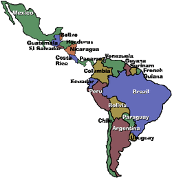
There are 29 countries in the region of Central and South America.
These countries are:
Mexico, Guatemala, El Salvador, Costa Rica, Ecuador, Colombia, Venezuela, Guyara, Suriname, Brazil, Barbados, Paraguay, Uruguay, Argentina, Chile, Bolivia, Peru, Cuba, Bahamas, Honduras, Haiti, Puerto Rico, Nicaragua, Belize, Jamaica, Dominican Republic, Trinidad and Tobago
Physical Features:
Feature 1
Panama Canal
The Panama Canal is significant to this region because it is essential for the shipping industry. The canal joins the Atlantic and Pacific Oceans and makes it possible for ships to pass through Central without having to sail around the entire continent of South America. For example if a ship were to sail from New York City to San Diego it would be more than 13,500 miles. Taking the route through the canal shortens the trip to around 5,500 miles. Panama Canal brings a lot of revenue into the area because it is such a popular tourist destination in the region. (Panama Canal Authority, 2010)
Feature 2
The Andes
The Andes are a mountain range located in South America. They run north to south along the western coast and stretch 4,500 miles. The Andes are one of the height mountain ranges in the world. The latitude is 10' North to 57' South. The longitude is 70' West to 80' East. The Andes is home to a variety of vegetation due to the varying climates. The region is home to rainforests in the North and a variety of animals, birds and reptiles. (Pulsipher & Pulsipher, 2008)
Feature 3
Atacama Desert
The Atacama Desert stretches from southern Peru into northern Chile and covers over 40,000 square miles. Its coordinates are 24'30' S and 69' 15' W. The area is noted for its lack of rainfall. According to National Geographic it is "The Driest Place on Earth". According to National Geographic there are stretches of the desert where rain has never been recorded, at least as long as humans have measured it. Because of the lack of moisture, nothing rots, just turns into artifacts. The most surprising information is that the Atacama is home to more than 1 million people. The population reside mostly in its coastal areas and mines. Farmers grow a variety of vegetation with drip-irrigation systems such as olives and tomatoes. (National Geographic, 2003)
Feature 4
Baja California
Baja California is a landmass that juts south of California and is a territory of Mexico. Its geography includes mountain ranges, beaches, forests and deserts. Its highest elevation is 10,171 feet. The Sierra de Baja California is a mountain range that runs throughout the middle of the region. The region is rich in minerals, citrus fruits and vegetation. This region is bordered on the west by the Pacific Ocean and on the east by the Gulf of California. Baja California has a Meditterranean climate in the north and an arid climate in the valleys. The area is prone to earthquakes because of its situation on the Andrea fault. (National Geographic, 2008)
Feature 5
Yucatan Peninsula
The Yucatan Peninsula is on the very southern tip of Mexico. It separates the Gulf of Mexico from the Caribbean Sea. Its coordinates are 18'50'42"N and 89'07'32"W. The Platform is made up mostly of limestone. The Lowlands of this region extend south of the peninsula. The Platform is home to one of the largest ongoing tracts of rainforest in Central America and is full of vegetation. The Peninsula is inhabited by the Mayans and the land is used for cattle ranching and logging. This Peninsula is a rich tourist area because of its most famous city, Cancun. (Frommers, 2011)
Climate:
Central and South America has a variety of climates. Tropical humid is the most prominent zone. The portion of the region that is spread across the equator experiences this climatic zone. The arid and semi-arid zones are on the western coast along the Pacific ocean. The temperate climates include the Mediterranean- is the dryness of summer, the subtropical- winter dryness and the mid altitude which is moist all year. The coldest climatic zones exist in the high altitude zones of the Andes. There are four temperature-altitude zones in Central and South America. The tierra caliente exists up to 3,000 feet. There is moisture in these regions which fosters the growth of tropical plants and produce. The tierra templada exists between 3,000-6,500 feet and this region is defined by its "perpetual Spring". This area also supports a variety of crops and coffe beans. The tierra fria is between 6,500-12,000 feet and includes many populated areas. The tierra helada is also referred to as the "frozen lands". It exists above 12,000 feet and while some plants can grow at its lowest point there is no vegetation higher up. (Pulsipher & Pulsipher, 2008)
Resources:
Resource 1
Coffee from Brazil
The coffee that comes from Brazil is responsible for a majority of the coffee produced in the world. Brazil is the world's largest producer of coffee and it produces more that 2 million tons per year. Brazil's coffee plantations cover more than 10,000 square miles and it is harvested in the summer months, between June and September. Coffee production in the region provides more than 7 million jobs and that is mostly in rural areas. (Souza, 2008)
Resource 2
Oil of Mexico
Mexico is a large producer of the world's oil. Production of oil in Mexico is the third largest producer in the Western hemisphere. Oil generates approximately 15 percent of the country's export income. The country produces about 3.3 million barrels of oil per day. There is a state oil company in Mexico, called PEMEX, that holds control over all of the state's oil production. Mexico produced most of its oil from 1979-2007 from Cantarell Field. The other major oil field in Mexico is Chicontepec Field. (Mexico Energy Data, 2011)
Environmental Issues:
Issue 1
Deforestation
The forests of the Amazons are being logged to clear the land to grow crops, extract oil and gas, and for the value of its lumber. After the land has been logged and farmed it is left depleted of nutrients and resources. The destruction of the rainforests is an environmental crisis on a global scale. The forests are responsible for converting carbon dioxide into oxygen through photosynthesis. The tropical areas do experience a higher rate of regrowth but it may still take 15-20 years to regain a forest. (Pulsipher & Pulsipher, 2008)
Issue 2
Air and Water Pollution
The metropolitan areas of Central and South America experience poor air and water quality due to rapid growth. The generation of wastes, release of chemicals, traffic emissions, and overburdened waste treatment facilities are causing large amounts of pollution. Residents are experiencing health problems such as respiratory diseases. The global impact is the effects the pollution is causing on the ozone and the dumping of wastes into the world's oceans. (Environmental Protection Agency, 2009)
Population Patterns:
Scientists dispute the timing of the settlement of Central and South America. It was settled approximately 14,000-30,000 years ago. People from Asia traveled to the region to fish and hunt. They traveled over the Bering land bridge. By 1492 when the Americas were discovered by Europeans there were 50-100 million inhabitants in the region. The Incas inhabited a vast portion of the area with most residing in the Andes. Today, internal population increases are more predominant than immigration. This is for a variety of reasons. The increase in medical care has decreased the death rate and there is a high birth rate in the region. According to a 2005 survey more than 560 million people are inhabiting the region. (Pulsipher & Pulsipher, 2008)
Role of Gender:
Families are a strong center of the community and lifestyle for the people of this region. Elderly relatives often reside in the home with younger generations. The church and its teachings are usually a strong center in the lives of the family. Women follow a set of values called marianismo. Marianismo is a moral guide for women that emphasizes service to the family and motherhood. Women in this region generally stay home to manage the day to day household and upbringing of children. Men are the providers for the family and work outside the home to provide the household income. Men in this region follow the model of machismo. Machismo is the guide of manliness, honor, attractiveness and respect that males in this region aspire to. (Pulsipher & Pulsipher, 2008)
Religions:
Religion 1
Catholicism
Since the early colonization of Central and South America Catholicism has been the largest religious institute in the region. Over the years the Church's power eroded as people began seeking relief for the poor. A populist movement began that started seizing and restructuring church property. This was called liberation theology. Today Catholicism remains the largest religion of the region but the Vatican now rules the churches. (Pulsipher & Pulsipher, 2008)
Religion 2
Evangelical Protestants
During the tumult of the populist movement Evangelical Protestants became another large religion in Central and South America. It remains one of the fastest growing religions in the region. This church appeals to the poor because it encourages hard work for success. The church is made up of independent congregations. It is debated that the church is responsible but the region has seen an increase in the middle class with the growth of this religion. (Pulsipher & Pulsipher, 2008)
Transportation:
In Central and South America the main modes of transportation are by air, railroad, air and the road way system. In South America the Inca Road system and Pan-American highway are the two main corridors of road way travel. In environmentally progressive countries, like Brazil, the public transportation system of the metro and express buses are gaining popularity and increasing in the region. There are various ports harbors located throughout this region for the import/export of goods and movement of people. South American airlines, as well as many other airline carriers, provide air transportation to hubs around the world. (Frommers, 2011)
Country of Focus:
Argentina
Argentina is the second largest country in South America and the largest Spanish speaking country. It is situated between the Andes Mountains and the Atlantic Ocean. Argentina is one of the largest economies of this region. It is located at 34'36'S and 58'23'W. The population is comprised of mostly Europeans (Italian and Spanish) with a population of more than 40 million people. The government of Argentina is established in much the same way as the United States. It is a democratic republic whose President is head of state and the government. Women hold high ranking positions throughout Argentina in contrast with other Central and South American countries. The climate ranges from tropical to polar. This is because of its location in proximity to the equator and the altitude its lands reach in conjunction with the Andes mountain ranges. Argentina has an abundance of natural resources. Its export earnings due to agriculture provided more that 50% of revenue to the country in 2010. Argentina is scientifically and technologically advanced for the region. It has contributed to major breakthroughs in medicine in the treatment for heart disease and many forms of cancer. The country is responsible for producing many doctors, scientist and Nobel Prize laureates. (CIA Factbook, 2011)
Cuisine:
While there are many common ingredients shared in the cuisine of South American dishes, each dish is unique to a different place. The agriculture of the area supplies the fresh ingredients used in that countries cuisine. Each country may make a similar dish, like empanadas, but each will be distinct to the ingredients they use. In Brazil beans, coconut, seafood, peanuts, and fruits are common ingredients. In Peru potatoes and grains are staple ingredients. Chile has a very distinct cuisine because of the large European influence. In Colombia, with their cattle ranching, many more dishes are meat based. (Pulsipher & Pulsipher, 2008)
References:
Pulsipher, L. & Pulsipher, A. (2008) World Regional Geography: Global Patterns, Local Lives (4th edition). New York: W & H Freeman & Company
Panama Canal Authority. (2010) Panama Canal. Retrieved from: http://www.pancanal.com/
CIA-The World Fact Book. (Feb, 2011) South America: Argentina. Retrieved from: http://www.cia.gov/libraby/publications
Mexico Energy Data. (June 2010) Mexico. Retrieved from: http://www.eia.doe.gov/cabs/Mexico/Background.html
Environmental Protection Agency. (Jan 2011) Environmental Issues of Mexico. Retrieved from: http://www.epa.gov/border 2012/issue.html
Earthquakes. (2005) Retrieved from: http://www.earthquakes.usgs.gov/
Frommers. (2010) Yucatan Penisula. Retrieved from: http://www.frommers.com/destinations/yucatanpeninsula/
Virtual Tourist. (2010) Tourism of South America. Retrieved from: http://www.virtualtourist.com/transportation/South_America
Souza, Ricardo M. (2008) Plant-Parasitic Nematodes of Coffee. Retrieved from: www.Amazon.com/Plant-Parasitic-Nematodes-Ricardo-Souza/
National Geographic. (2003) The Driest Place on Earth. Retrieved from: http://ngm.nationalgeographic.com/ngm
Photos: Creative Commons. (2011) Retrieved from: http://www.weebly.com/