Regional Overview of Sub-Saharan Africa
There are 42 countries in this region.
Madagascar, South Africa, Botswana, Nambia, Zimbabwe, Mozambique, Comoros, Seychelles, Malawi, Zambia, Angola, Tanzania, Democratic Republic of the Congo, Republic of Congo, Gabon, Cameroon, Central African Republic, Kenya, Uganda, Somalia, Ethiopia, Djibouti, Eritrea, Sao Tome and Principe, Equatorial Guinea, Nigeria, Chad, Niger, Mali, Benin, Togo, Ghana, Burkina Faso, Cote Divoire, Liberia, Guinea, Sierra Leone, Mauritania, Senegal, Cape Verde, Guinea Bissau, The Gambia.
Physical Features:
Feature 1
Kalahari Desert
The Kalahari Desert is one of Africa's largest game reserves. It is a sanctuary for many different species of birds and animals. The desert is over 350,000 square miles. It is part of a huge sand basin that reaches from the Orange River up to Angola, in the west to Namibia and in the east to Zimbabwe. Its coordinates are 23' S and 23' E. The dominant vegetation is grass, thorny shrubs and Acacia trees which can survive long drought periods of more than ten months every year. The sand masses were created by the erosion of soft stone formations. Only in recent geological history, 10,000 to 20,000 years ago, were the dunes stabilized through vegetation. The Orange River runs through the desert and the highest point is Brandberg Mountain at 8,500 feet. (South Africa Travel, 2011)
Feature 2
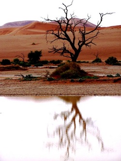
Namib Desert
The Namib Desert extends 1,200 miles from Namibe along the entire coast of Namibia in South Africa. It experiences very little to no rainfall. It is basically a smooth platform of bedrock of various types. The southern half of the platform is covered in sand and the desert is home to a variety of plant and animal species. Marine animals populate the shore areas including pelicans, antelope, flamingos, and penguins. The Namib is divided into three subregions: the narrow coastal region along the Atlantic; the Outer Namib, the western half, and the Inner Namib, the eastern side. (Britannica, 2011)
Feature 3
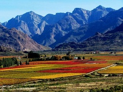
Kenya Highlands
The Central Highlands of Kenya is a very fertile, intensely cultivated region northwest of Nairobi. The highlands surround the Aberdares Mountain Range. The region is home to the Kikuyu people who regard the the land as sacred. The region is also home to two national parks, Mt. Kenya and Aberdare. The land experiences abundant rainfall so it great for the area's agriculture. Tea, coffee, pine and eucalyptus thrive in the higher elevations while oranges, maize, pineapples and bananas grow in the lower regions. Major environmental concerns disrupt this region. Soil erosion and deforestation claim more and more land every year. (Jambo Kenya, 2010)
Feature 4
Ethiopian Highlands
The Ethipian Highlands are home to a wide variety of animal species. More than 30 bird species, 13 amphibians and many plants can be found. The Highlands are 104,000 square miles and the Highlands cover sections of Eritrea, Ethiopia, and Sudan. The Highlands were formed with the remains of volcanoes in northeastern Africa. The climate of this region is arid to semi arid and little rainfall is experienced throughout the year. The Ethiopian Highlands are among the most densely populated agricultural areas in Africa. (PBS, 2011)
Feature 5
Katanga Plateau
The Katanga Plateau is located in the Democratic Republic of the Congo. It is used for farming. Agriculture in this region includes cotton, tobacco, corn, vegetables and cattle. Its highest elevation is 6,000 feet. It is also called the Shaba Plateau with Shaba being the Swahili word for copper. This region's mines yield most of the Congo's copper, cobalt, uranium, zinc, silver, coal, iron and tin. The area is inhabited by native peoples who depend on its vast resources. (Britannica, 2011)
Climate:
Most of the region has a tropical climate and the reason is because 70 percent of the region lies on the Tropic of Cancer and the Tropic of Capricorn. The Intertropical Convergence Zone or ITCZ causes much of this region's rain because it is the atmospheric currents that circle the globe and the equator. Other climate zones in this region include tropical humid, arid and semiarid in the vast deserts, and temperate climates. The Horn of Africa experiences no rain. Challenges in this region due to the climate are minerals are leached or washed out from the soil which makes shifting cultivation necessary. (Pulsipher & Pulsipher, 2008)
Resources:
Resource 1-Minerals
South Africa exports many different minerals. It produces 27 percent of the world's gold and 50 percent of its platinum. It also produces two thirds of the world's diamonds. Many of these diamonds are referred to as "blood" diamonds or conflict diamonds because of the forced labor that people have to endure for their extraction in conflict ridden, war torn regions. The World Diamond Congress passed a resolution in 2000 to stop the diamond industry from accepting any of these diamonds in the global market. The US also enacted the Clean Diamond Trade Act in 2003 to make the sale of diamonds in US stores transparent. This means each diamond must have the papers and proof that they were not extracted from these areas. (Pulsipher & Pulsipher, 2008)
Resource 2-Agriculture
Agriculture is the staple of this region's economy. More than 66 percent of Africans live in rural areas and depend on agriculture for their livelihoods. Today the cash crops of this region include peanuts, cacao beans, rice, vegetables, grain, animals and coffee. (Pulsipher & Pulsipher & Pulsipher, 2008)
Environmental Issues:
Issue 1-Desertification
Desertification is when arid conditions spread to areas that were previously moist. Climatologists think that parts of Africa undergo this as a natural cycle and not caused by global warming. Indigenous animal herders are commonly blamed for increased desertification because many believe the herders let there animals graze until there is no plant life left. Without the plant life the soil cannot hold or retain moisture and the land becomes sandy and barren. The overharvesting of trees in this region for fuel wood also leads to desert like lands. (Pulsipher & Pulsipher, 2008)
Issue 2-Water
Because of the lack of water in this region there is a lot of irrigation. The agriculture of Africa takes up 70 percent of its water resources and the projects are mostly irrigated. These systems lose a lot of water due to leakage and evaporation. Standing pools of water are often riddled with pesticides and insects and are unsafe for use. Human wastes, pollutants and chemical poisons are quickly contaminating the small amounts of usable water that this continent has left. Because much of this continent's population lives in rural regions without indoor plumbing most of the water becomes contaminated by human waste. (Pulsipher & Pulsipher, 2008)
Population Patterns:
Because of limited resources the population is unevenly distributed. The carrying capacity, which is the maximum number of people the land can support sustainably with food, water and other resources varies greatly on the continent because of the vast arid regions. The population of Africa is the largest growing in the world. In 50 years the population of Africa more than tripled, reaching 657 million people in 2000 and between the years 2000-2006 the population grew by another 100 million people. Childlessness is considered a tragedy among the people of this region. Families are large and expanding more every day. This region just does not have the resources to support the abundance of people. (Pulsipher & Pulsipher, 2008)
Role of Gender:
Women- Women in this region are responsible for the domestic duties of the family. These duties include raising children, maintaining the home and tending to all members of the family. Women are also primarily responsible for carrying all the firewood and producing all the meals. They also cultivate most of the rice grown in this region. There is a brutal practice that has been going on in Africa which is widespread. To ensure that women remain virgins until their wedding a form of female circumcision is performed. It is also called cutting. Due to this brutal practice of cutting off parts of a woman's vital organ many more women in this country die in childbirth. The tissue becomes inelastic and scar tissue forms making sex and childbirth painful.
Men- Men in this region practice polygyny which is a form of polygamy and involves a man having more than one wife. Men in this region do not have as many responsibilities as women. They are primarily responsible for bringing in the income of the family but do not have to work as hard as women to earn their incomes. They are also responsible for cultivating the land for the women to plant the rice and crops. (Pulsipher & Pulsipher, 2008)
Religions:
Religion 1-Indigenous Belief Systems
Indigenous beliefs are the belief system, outside of Islam, that is the most common and widespread belief system throughout Africa. The indigenous beliefs of the African people are the traditional African religions with the most ancient history on earth. In these beliefs the Africans feel that all entities, be it plants, animals, and the landscape, are part of a whole that includes the entire environment. They belief that the spirits of their deceased surround them. The spirits are in the trees, streams, rivers, hills and art objects they create. The spirits are believed to offer protection in return for the respect they are shown. These beliefs evolve as new influences from outside religions are encountered. Even if a person converts to a different religion they often incorporate their indigenous heritage into their beliefs. (Pulsipher & Pulsipher, 2008)
Religion 2-Islam
Islam is the most widespread religion in this area of the world. After Muhammad's death in 632 AD Islam spread to East Africa. It is now the predominant religion throughout Africa and much of the world. Islamic leaders are politically powerful in Nigeria and other parts of west Africa. Many religious conflicts arise in this region and surrounding regions due to the different interpretations of the Islam religion. Extremist groups in Africa perform genocide on the people in these conflict zones. (Pulsipher & Pulsipher, 2008)
Transportation:
The African Transport Unit (AFTTR) is working to develop reliable, cost effective, and safe transportation in Sub-Saharan Africa. Before the 1980's most transport businesses were publicly owned and managed. The methods of transportation in this region include railways, bus and trucking, airports and seaports. These businesses were operating at a loss because of the heavy regulations and poor cost recovery. Since this time the transportation sector has been mostly deregulated and privatized. The privatization means companies can now enforce permit meters. The Sub-Saharan Transport Program (SSATP) was created for the main roadways and rural transport to encourage safe and environmentally friendly transit. (World Bank, 2004)
Agriculture:
Women contribute more than 70 percent of the time spent on agriculture in this region. While men cultivate the soil for planting, women are responsible for planting and tending to the rice and crops. Rice is grown throughout the region but scarce precipitation makes the growing of agriculture very difficult. More than 60 percent of Africans produce their own food by farming. Peanuts, cacao beans, rice and coffee are staples in the agriculture, bringing in the livelihoods of many Africans. Mixed agriculture is also practiced. Mixed agriculture is the raising of cattle or livestock in conjunction with rice and crops. Pastoralism is also commonly practiced in the savanna or desert regions. Pastoralism is the practice of herding animals for the trade of meat, milk and hides for grain and vegetables. (Pulsipher & Pulsipher, 2008)
Country of Focus:
Malawi
Malawi is located in southeast Africa. It is bordered by Zambia to the northwest, Tanzania to the northeast, and Mozambique. Malawi's population is more than 14 million people. It is one of the least developed countries in the world with one of the densest populations. The government relies on foreign aid as much of this country's economy is based on agriculture. Malawi has a democratic government and one of the primary languages spoken is English. The country gained its independence from the United Kingdom in 1964. There is a high prevalence of AIDS/HIV in this region and a low life expentancy and high infant mortality rate. This is due to the poor healthcare system that the government is working on improving. The population is very culturally and ethnically diverse. Several languages are spoken and many religious beliefs observed. The climate is hot in low lands and temperate in the northern highlands. More than 80 percent of the population lives in rural areas and more than 90 percent of revenue comes from agriculture. Tobacco, cotton, tea, sugarcane, corn, potatoes, and cattle are the main agricultural products. More than 80 percent of the population is Christian. Dance is a popular activity in this region. The government formed a Dance Troupe in 1987. Soccer is the main sport of the region. (BBC, 2008)
Resources:
Pulsipher, L. & Pulsipher, A. (2008) World Regional Geography: Global Patterns, Local Lives (4th Edition)
New York: W.H. Freeman Company
BBC News. (2008) Country Profile: Malawi. Retrieved from: http://news.bbc.co.uk/1/hi/world/africa/country_profiles/1068913
World Bank. (2004) Sub-Saharan Transport. Retrieved from: http://web.worldbank.org/WBSITE/EXTERNAL/COUNTRIES/AFRICAEXT/0
South Africa Travel. (2011) Kalahari Desert, South Africa. Retrieved from: http://www.southafrica-travel.net/kalahari
Jambo Kenya. (2010) Central Highlands. Retrieved from: http://www.jambokenya.com/jambo/location/central.htm
Encyclopedia of Britannica. (2011). Namib. Retrieved from: http://www.britannica.com/EBchecked/topic/402264/Namib
Encyclopedia of Britannica. (2011). Katanga. Retrieved from: http://www.britannica.com/EBchecked/topic/313141/Katanga
PBS. (2011). Ethiopian Highlands. Retrieved from: http://www.pbs.org/wnet/africa/explore/ethiopia/ethiopia_overview_lo.html
Photos: Creative Commons. (2011). Retrieved from: http://www.weebly.com/
Madagascar, South Africa, Botswana, Nambia, Zimbabwe, Mozambique, Comoros, Seychelles, Malawi, Zambia, Angola, Tanzania, Democratic Republic of the Congo, Republic of Congo, Gabon, Cameroon, Central African Republic, Kenya, Uganda, Somalia, Ethiopia, Djibouti, Eritrea, Sao Tome and Principe, Equatorial Guinea, Nigeria, Chad, Niger, Mali, Benin, Togo, Ghana, Burkina Faso, Cote Divoire, Liberia, Guinea, Sierra Leone, Mauritania, Senegal, Cape Verde, Guinea Bissau, The Gambia.
Physical Features:
Feature 1
Kalahari Desert
The Kalahari Desert is one of Africa's largest game reserves. It is a sanctuary for many different species of birds and animals. The desert is over 350,000 square miles. It is part of a huge sand basin that reaches from the Orange River up to Angola, in the west to Namibia and in the east to Zimbabwe. Its coordinates are 23' S and 23' E. The dominant vegetation is grass, thorny shrubs and Acacia trees which can survive long drought periods of more than ten months every year. The sand masses were created by the erosion of soft stone formations. Only in recent geological history, 10,000 to 20,000 years ago, were the dunes stabilized through vegetation. The Orange River runs through the desert and the highest point is Brandberg Mountain at 8,500 feet. (South Africa Travel, 2011)
Feature 2
Namib Desert
The Namib Desert extends 1,200 miles from Namibe along the entire coast of Namibia in South Africa. It experiences very little to no rainfall. It is basically a smooth platform of bedrock of various types. The southern half of the platform is covered in sand and the desert is home to a variety of plant and animal species. Marine animals populate the shore areas including pelicans, antelope, flamingos, and penguins. The Namib is divided into three subregions: the narrow coastal region along the Atlantic; the Outer Namib, the western half, and the Inner Namib, the eastern side. (Britannica, 2011)
Feature 3
Kenya Highlands
The Central Highlands of Kenya is a very fertile, intensely cultivated region northwest of Nairobi. The highlands surround the Aberdares Mountain Range. The region is home to the Kikuyu people who regard the the land as sacred. The region is also home to two national parks, Mt. Kenya and Aberdare. The land experiences abundant rainfall so it great for the area's agriculture. Tea, coffee, pine and eucalyptus thrive in the higher elevations while oranges, maize, pineapples and bananas grow in the lower regions. Major environmental concerns disrupt this region. Soil erosion and deforestation claim more and more land every year. (Jambo Kenya, 2010)
Feature 4
Ethiopian Highlands
The Ethipian Highlands are home to a wide variety of animal species. More than 30 bird species, 13 amphibians and many plants can be found. The Highlands are 104,000 square miles and the Highlands cover sections of Eritrea, Ethiopia, and Sudan. The Highlands were formed with the remains of volcanoes in northeastern Africa. The climate of this region is arid to semi arid and little rainfall is experienced throughout the year. The Ethiopian Highlands are among the most densely populated agricultural areas in Africa. (PBS, 2011)
Feature 5
Katanga Plateau
The Katanga Plateau is located in the Democratic Republic of the Congo. It is used for farming. Agriculture in this region includes cotton, tobacco, corn, vegetables and cattle. Its highest elevation is 6,000 feet. It is also called the Shaba Plateau with Shaba being the Swahili word for copper. This region's mines yield most of the Congo's copper, cobalt, uranium, zinc, silver, coal, iron and tin. The area is inhabited by native peoples who depend on its vast resources. (Britannica, 2011)
Climate:
Most of the region has a tropical climate and the reason is because 70 percent of the region lies on the Tropic of Cancer and the Tropic of Capricorn. The Intertropical Convergence Zone or ITCZ causes much of this region's rain because it is the atmospheric currents that circle the globe and the equator. Other climate zones in this region include tropical humid, arid and semiarid in the vast deserts, and temperate climates. The Horn of Africa experiences no rain. Challenges in this region due to the climate are minerals are leached or washed out from the soil which makes shifting cultivation necessary. (Pulsipher & Pulsipher, 2008)
Resources:
Resource 1-Minerals
South Africa exports many different minerals. It produces 27 percent of the world's gold and 50 percent of its platinum. It also produces two thirds of the world's diamonds. Many of these diamonds are referred to as "blood" diamonds or conflict diamonds because of the forced labor that people have to endure for their extraction in conflict ridden, war torn regions. The World Diamond Congress passed a resolution in 2000 to stop the diamond industry from accepting any of these diamonds in the global market. The US also enacted the Clean Diamond Trade Act in 2003 to make the sale of diamonds in US stores transparent. This means each diamond must have the papers and proof that they were not extracted from these areas. (Pulsipher & Pulsipher, 2008)
Resource 2-Agriculture
Agriculture is the staple of this region's economy. More than 66 percent of Africans live in rural areas and depend on agriculture for their livelihoods. Today the cash crops of this region include peanuts, cacao beans, rice, vegetables, grain, animals and coffee. (Pulsipher & Pulsipher & Pulsipher, 2008)
Environmental Issues:
Issue 1-Desertification
Desertification is when arid conditions spread to areas that were previously moist. Climatologists think that parts of Africa undergo this as a natural cycle and not caused by global warming. Indigenous animal herders are commonly blamed for increased desertification because many believe the herders let there animals graze until there is no plant life left. Without the plant life the soil cannot hold or retain moisture and the land becomes sandy and barren. The overharvesting of trees in this region for fuel wood also leads to desert like lands. (Pulsipher & Pulsipher, 2008)
Issue 2-Water
Because of the lack of water in this region there is a lot of irrigation. The agriculture of Africa takes up 70 percent of its water resources and the projects are mostly irrigated. These systems lose a lot of water due to leakage and evaporation. Standing pools of water are often riddled with pesticides and insects and are unsafe for use. Human wastes, pollutants and chemical poisons are quickly contaminating the small amounts of usable water that this continent has left. Because much of this continent's population lives in rural regions without indoor plumbing most of the water becomes contaminated by human waste. (Pulsipher & Pulsipher, 2008)
Population Patterns:
Because of limited resources the population is unevenly distributed. The carrying capacity, which is the maximum number of people the land can support sustainably with food, water and other resources varies greatly on the continent because of the vast arid regions. The population of Africa is the largest growing in the world. In 50 years the population of Africa more than tripled, reaching 657 million people in 2000 and between the years 2000-2006 the population grew by another 100 million people. Childlessness is considered a tragedy among the people of this region. Families are large and expanding more every day. This region just does not have the resources to support the abundance of people. (Pulsipher & Pulsipher, 2008)
Role of Gender:
Women- Women in this region are responsible for the domestic duties of the family. These duties include raising children, maintaining the home and tending to all members of the family. Women are also primarily responsible for carrying all the firewood and producing all the meals. They also cultivate most of the rice grown in this region. There is a brutal practice that has been going on in Africa which is widespread. To ensure that women remain virgins until their wedding a form of female circumcision is performed. It is also called cutting. Due to this brutal practice of cutting off parts of a woman's vital organ many more women in this country die in childbirth. The tissue becomes inelastic and scar tissue forms making sex and childbirth painful.
Men- Men in this region practice polygyny which is a form of polygamy and involves a man having more than one wife. Men in this region do not have as many responsibilities as women. They are primarily responsible for bringing in the income of the family but do not have to work as hard as women to earn their incomes. They are also responsible for cultivating the land for the women to plant the rice and crops. (Pulsipher & Pulsipher, 2008)
Religions:
Religion 1-Indigenous Belief Systems
Indigenous beliefs are the belief system, outside of Islam, that is the most common and widespread belief system throughout Africa. The indigenous beliefs of the African people are the traditional African religions with the most ancient history on earth. In these beliefs the Africans feel that all entities, be it plants, animals, and the landscape, are part of a whole that includes the entire environment. They belief that the spirits of their deceased surround them. The spirits are in the trees, streams, rivers, hills and art objects they create. The spirits are believed to offer protection in return for the respect they are shown. These beliefs evolve as new influences from outside religions are encountered. Even if a person converts to a different religion they often incorporate their indigenous heritage into their beliefs. (Pulsipher & Pulsipher, 2008)
Religion 2-Islam
Islam is the most widespread religion in this area of the world. After Muhammad's death in 632 AD Islam spread to East Africa. It is now the predominant religion throughout Africa and much of the world. Islamic leaders are politically powerful in Nigeria and other parts of west Africa. Many religious conflicts arise in this region and surrounding regions due to the different interpretations of the Islam religion. Extremist groups in Africa perform genocide on the people in these conflict zones. (Pulsipher & Pulsipher, 2008)
Transportation:
The African Transport Unit (AFTTR) is working to develop reliable, cost effective, and safe transportation in Sub-Saharan Africa. Before the 1980's most transport businesses were publicly owned and managed. The methods of transportation in this region include railways, bus and trucking, airports and seaports. These businesses were operating at a loss because of the heavy regulations and poor cost recovery. Since this time the transportation sector has been mostly deregulated and privatized. The privatization means companies can now enforce permit meters. The Sub-Saharan Transport Program (SSATP) was created for the main roadways and rural transport to encourage safe and environmentally friendly transit. (World Bank, 2004)
Agriculture:
Women contribute more than 70 percent of the time spent on agriculture in this region. While men cultivate the soil for planting, women are responsible for planting and tending to the rice and crops. Rice is grown throughout the region but scarce precipitation makes the growing of agriculture very difficult. More than 60 percent of Africans produce their own food by farming. Peanuts, cacao beans, rice and coffee are staples in the agriculture, bringing in the livelihoods of many Africans. Mixed agriculture is also practiced. Mixed agriculture is the raising of cattle or livestock in conjunction with rice and crops. Pastoralism is also commonly practiced in the savanna or desert regions. Pastoralism is the practice of herding animals for the trade of meat, milk and hides for grain and vegetables. (Pulsipher & Pulsipher, 2008)
Country of Focus:
Malawi
Malawi is located in southeast Africa. It is bordered by Zambia to the northwest, Tanzania to the northeast, and Mozambique. Malawi's population is more than 14 million people. It is one of the least developed countries in the world with one of the densest populations. The government relies on foreign aid as much of this country's economy is based on agriculture. Malawi has a democratic government and one of the primary languages spoken is English. The country gained its independence from the United Kingdom in 1964. There is a high prevalence of AIDS/HIV in this region and a low life expentancy and high infant mortality rate. This is due to the poor healthcare system that the government is working on improving. The population is very culturally and ethnically diverse. Several languages are spoken and many religious beliefs observed. The climate is hot in low lands and temperate in the northern highlands. More than 80 percent of the population lives in rural areas and more than 90 percent of revenue comes from agriculture. Tobacco, cotton, tea, sugarcane, corn, potatoes, and cattle are the main agricultural products. More than 80 percent of the population is Christian. Dance is a popular activity in this region. The government formed a Dance Troupe in 1987. Soccer is the main sport of the region. (BBC, 2008)
Resources:
Pulsipher, L. & Pulsipher, A. (2008) World Regional Geography: Global Patterns, Local Lives (4th Edition)
New York: W.H. Freeman Company
BBC News. (2008) Country Profile: Malawi. Retrieved from: http://news.bbc.co.uk/1/hi/world/africa/country_profiles/1068913
World Bank. (2004) Sub-Saharan Transport. Retrieved from: http://web.worldbank.org/WBSITE/EXTERNAL/COUNTRIES/AFRICAEXT/0
South Africa Travel. (2011) Kalahari Desert, South Africa. Retrieved from: http://www.southafrica-travel.net/kalahari
Jambo Kenya. (2010) Central Highlands. Retrieved from: http://www.jambokenya.com/jambo/location/central.htm
Encyclopedia of Britannica. (2011). Namib. Retrieved from: http://www.britannica.com/EBchecked/topic/402264/Namib
Encyclopedia of Britannica. (2011). Katanga. Retrieved from: http://www.britannica.com/EBchecked/topic/313141/Katanga
PBS. (2011). Ethiopian Highlands. Retrieved from: http://www.pbs.org/wnet/africa/explore/ethiopia/ethiopia_overview_lo.html
Photos: Creative Commons. (2011). Retrieved from: http://www.weebly.com/