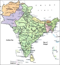
Regional Overview of South Asia

There are eight countries in this region:
India
Pakistan
Afghanistan
Sri Lanka
Nepal
Bangladesh
Bhutan
Maldives
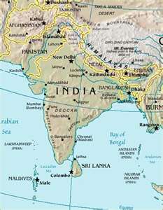
Physical Features:
Feature 1- Western Ghats
The Western Ghats run along the west coast of India and cover more than 61,000 square miles. This area is densely populated by a rich biodiversity of different animal and plant species. It is estimated that as many as 10,000 elephants can be found roaming freely in the southwestern portion of the Western Ghats. The area used to be covered in forests but deforestation and the increased settling by local people has changed the landscape. In the northern part of this region more than half the reptiles, three-fourths of amphibians and one third of India's plant life can be found in the narrow strip of rainforest. (World Wildlife Federation, 2011)
Feature 2-Eastern Ghats
The Eastern Ghats are a range of mountains that extend along India's eastern shore. It runs through the Indian states of West Bengal, Orissa, Jharkhand, ANdhra Pradesh, and Tamil Nadu. The highest peak is Biligirirangan Hills at 5091 feet and its orientation is 15'47'N and 80'54'E. The Eastern Ghats cover 101,418 square miles. Four rivers run through the mountain range: the Godavari, Mahandi, Krishna and Kaveri. The mountain range runs parallel to the Bay of Bengal. The climate of the Eastern Ghats is cool and wet. It is the home to many coffee plantations that support the local economy. (Peak Bagger, 2004)
Feature 3-Ganges River
The Ganges River flows 1,560 miles through the Indian states of Uttar Pradesh, Bihar and West Bengal. Its orientation is 22'05'N and 90'50' E. The shores of this river are some of the most fertile and densely populated lands in the world. Hundreds of millions of people live along its shores and rely on it for transportation and its water. It is considered a holy place among Hindus. Each year millions of Hindus bathe in its waters and many cast the ashes of the deceased. The river flows from northwest to southeast and its delta flow is south. (Encyclopedia of Britannica, 2010)
Feature 4-Nilgiri Hills
The Nilgiri HIlls are a range of mountains in South India. The Nilgiri Hills have 24 peaks above 6,500 feet. They are a part of the Western Ghats and its orientation is 11'22' N and 76'45' E. The Nilgiri Hills have an area of 950 square feet. The highest point is Doddabetta Peak at 8,652 feet. The Hills are home to over 2700 species of flowering plant life and dozens of waterfalls making it a beautiful tourist destination. (Encyclopedia of Britannica, 2010)
Feature 5-Satpura Range
The Satpura Range is located in India in the states of Madhya Pradesh, Mahashtra, and Chhatisgarh. Its orientation is 22'27'2"N and 78'22'14'E. The Range is a tourist destination in India and helps support the local economy. Many worshippers visit the Gorakhnath Temple and it is also a popular destination for hiking, fishing and other water activities. Most of the forests have been destroyed due to the tourists and deforestation. The Satpura Range is home to a diverse group of animal and plant life including tigers and sloths. The highest point is Dhupgarh at 4,400 feet and several rivers flow through the range. (Encyclopedia of Britannica, 2010)
Climate:
There are a variety of climatic zones in this region. Tropical humid, arid and semiarid, temperate, cool humid and cold int he mountain regions are the climates of this area. Monsoons are known in this region and are wind patterns that bring about heavy rains. In winter, cool, dry air flows from the Eurasian continent to the ocean and in the summer, warm, moisture laden air flows from the Indian Ocean over the Indian continent. The ITCZ is the intertropical convergence zone. This is an air mass the moves south from the Northern hemisphere and converges near the equator producing precipitation. (Pulsipher & Pulsipher, 2008)
Population Patterns:
The large population growth is straining the resources in South Asia. Currently there are more people in South Asia than in China. India's population alone is expected to overtake China's population within the next 10 years. India adds more than 18 million people a year to its population. South Asia has been attempting population control by reducing birth rates since 1952. Over a billion dollars a year is spent in India on these efforts and fertility rates have declined. The most populated area in this region is near the Himalayan Mountain range in northern India. (Pulsipher & Pulsipher, 2008)
Resources:
Resource 1-Agriculture
More than 60 percent of this region's population engages in agricultural labor. Agriculture is the lowest return on investments and only makes up around 25 percent of the GDP. Agricultural products grown are cotton, rice, wheat, millet, and sorghum. A green revolution took place in the 1960's that boosted grain harvest dramatically through the use of new tools and techniques. Where these techniques were used the harvest became more bountiful and countries were able to become food exporters thereby increasing the local economies. (Pulsipher & Pulsipher, 2008)
Resource 2-Oil
South Asia is a rich source of petroleum and natural gas. Due to recent technilogical developments this region in the world has become one of the most active in offshore oil exploration. South Asia produces more than 2 million gallons of oil per day. (Pulsipher & Pulsipher, 2008)
Environmental Issues:
Issue 1-Deforestation
Deforestation has been going on since the early history of this region. In the 21st century the forests are still shrinking due to commercial logging and the expansion of local villages. Trails are continuously being created for tourist treks in the mountain regions. The forests are additionally being depleted by these tourists as they cut the wood for camping. Locals rely on the wood for their heat source and cooking needs. The Social Forestry Movement was begun by a group of local women. The women would hug trees when the loggers came and would not leave the trees until the loggers left in an effort to save their forests. This movement spread to other areas and slowed the deforestation and increased ecological awareness. There is a strong desire in this area to save the ecological features of this land. Ecological activism has become a growing trend to save the environment. (Pulsipher & Pulsipher, 2008)
Issue 2-Water Issues
South Asia has more than 20 percent of the world's water. However, only 4 percent of this is freshwater. The lack of drinking water creates conflicts. India and Bangladesh have disputes over access to the waters of the Ganga River. India has even diverted more than 60 percent of the river's flow into Kolkata. This practice is depriving Bangladesh of drinkable water. This has damaged Bangladesh's coastline and further hurt their fishing industry. Bangladesh relies heavily on the fishing industry as part of the local economy and India's practices have put more than 40 million rural people of Bangladesh's livelihoods at risk. In the late 1990's India signed a treaty promising to distribute more water. This has proven difficult to achieve. The region is poor and resources are limited to make this happen. (Pulsipher & Pulsipher, 2008)
Role of Gender:
Women's status in this region is generally lower than men. Women's status improves in areas of India and in Sri Lanka but, remain very low in the countries of Afghanistan, Pakistan, western India and Bangladesh. Education is available to women in urban areas and many women do hold high ranking positions in the governments. The women of Afghanistan have the strictest lives of all women in this region due to the control the Taliban had over the society. While the Taliban has been ousted their control over the people remains evident. Men and women in Afghanistan follow a very rigid set of rules set by this extremist Islamic group. Girls and women were not allowed to leave the home under the regime and had to remain completely concealed by a burqa whenever they did live the house, almost always accompanied by a male relative. Marriages in this region are often arranged with a family offering a dowry to the groom's family at the time of marriage. Horrible instances of "bride burning" have taken place in this region. "Bride burning" is when a new husband and his family will stage an accident involving the death of the new wife to collect the dowry. This allows the man to marry again and collect another dowry. There are organizations in this region that are working to improve the lives of women. The India Literacy Project and the South Asian Women's Network are seeking to diminish the restrictions placed on women and encourage education and learning trades so that women are skilled to join the workforce. (Pulsipher & Pulsipher, 2008)
Religions:
Religion 1-Hinduism
Hinduism is the major world religion practiced by approx. 900 million people-800 million people live in India. It is a complex belief system with a broad range of beliefs and practices. There is a highly localized folk belief system that varies depending on the area. Vedas are the Hindu scriptures. The teachings of the Vedas are that all gods are manifestation of ultimate divinity. Hindus have a strong belief in reincarnation. Reincarnation is the belief that any living thing that desires illusory pleasures and pains of life will be reborn after it dies. Hinduism also practices a reverance for cows. Cows are sacred to the Hindu's and therefore they do not consume any of their meat or milk. (Pulsipher & Pulsipher, 2008)
Religion 2-Buddhism
Buddhism is a belief system that began about 2600 years ago as a reinterpretation of Hinduism. Buddhism originated in India and spread easterward throughout Southeast Asia. Only 1 percent of the population, or roughly 10 million people, practice Buddhism in Southeast Asia. The majority of believers live in Bhutan and Sri Lanka. (Pulsipher & Pulsipher, 2008)
Transportation:
Waterway transport, road ways, rail travel and airports make up the transportation corridors of this region. The National Highways was rebuilt when the Pakistani government began reconstruction on the roadways in the 1990's. The project is still ongoing and the use of roadways continues to grow because more people have cars in this region. Bangladesh has faced many obstacles in developing its roadway system because of the terrain. Bangladesh has an extensive river system and construction costs for this country are high because of the necessity of bridges. Sri Lanka has continued to build its road system since private road transportation expanded in the 1970s and 1980s. The Indian Railways provides rail transportation to much of the region. It is the largest railway system in Asia and the fifth largest in the world. It was developed when 42 separate railway system were interconnected forming one massive railway system through the countries. Air transportation is the most modern and quickest mode of transport. The Orient Airways provides flights within this region and to the world. The rivers have been used as a transport system since the original peoples populated this region and are used heavily today. (CIA Factbook, 2009)
GDP and HDI:
This region has very low rankings in GDP and HDI. The low numbers of South Asia are almost as low as Africa's. The reason for this is the large population of people who live in poverty. The people of this region are frugal and resourceful. They grow their own food, recycle all of their resources and limit their cash expenditures. Tourism plays a huge role in the local economy. This leads to some countries having higher GDP and HDIs. Because of the continuous wars and conflicts in this region some countries rankings are greatly affected. The Taliban's influence in certain countries of this region have a significant affect on their rankings. (Pulsipher & Pulsipher, 2008)
Country of Focus:
India
India is approximately one third the size of the United States at 1.27 million square feet. The capital is New Delhi. The climate ranges from Alpine to temperate to tropical monsoon. There is a population of more than 1.2 billion people living in India. The largest religion is Hinduism and Hindi is one of the official languages. The work force is made up of more than 430 million people. The natural resources of India are coal, iron ore, manganese, bauxite, thorium, limestone, barite, titanium ore, diamonds and crude oil. Agriculture makes up 17% of the countries GDP and the products produced are wheat, rice, grains, sugar, cotton, just and tea. The industry sector makes up another 28% of the GDP producing textiles, steel, machinery, cement, transport equipment, petroleum, chemicals and computer software. The services and transport sector make up the remaining percentage of the GDP. India supports over 15% of the world's population, only China has a larger population. The median age in India is 25 making it one of the lowest age ranges among the world's economies. The people of India have been a continuous civilization since 2500BC. India has a federal form of government. The central government of India has far more power in relation to the states and has a British style Parliamentary system. India's GDP continues to grow and their economy has fared well in relation to the worldwide economic downturn that took place in recent years. (US Department of State, 2011)
Resources:
Pulsipher, A. & Pulsipher, L. (2008) World Regional Geography: Global Patterns, Local Lives (4th Edition)
New York: W.H. Freeman Company
World Wildlife Federation. (2011) Western Ghats, India. Retrieved from: http://wwf.panda.org
CIA Factbook. (2009) Transportation in India. Retrieved from: http://www.cia.gov/library/publications/the-world-factbook/india-transportation
Encyclopedia of Britannica. (2010) Ganges River, Asia. Retrieved from: http://www.britannica.com/EBchecked/topic/225359/Ganges-River
Peak Bagger. (2004) Eastern Ghats. Retrieved from: http://www.peakbagger.com/range.aspx?rid=493
The US Department of State. (2011) Background Note: India. Retrieved from: http://www.state.gov/r/pa/ei/bgn/2454.htm
Photos: Creative Commons. (2011) Retrieved from: http://www.weebly.com/
India
Pakistan
Afghanistan
Sri Lanka
Nepal
Bangladesh
Bhutan
Maldives
Physical Features:
Feature 1- Western Ghats
The Western Ghats run along the west coast of India and cover more than 61,000 square miles. This area is densely populated by a rich biodiversity of different animal and plant species. It is estimated that as many as 10,000 elephants can be found roaming freely in the southwestern portion of the Western Ghats. The area used to be covered in forests but deforestation and the increased settling by local people has changed the landscape. In the northern part of this region more than half the reptiles, three-fourths of amphibians and one third of India's plant life can be found in the narrow strip of rainforest. (World Wildlife Federation, 2011)
Feature 2-Eastern Ghats
The Eastern Ghats are a range of mountains that extend along India's eastern shore. It runs through the Indian states of West Bengal, Orissa, Jharkhand, ANdhra Pradesh, and Tamil Nadu. The highest peak is Biligirirangan Hills at 5091 feet and its orientation is 15'47'N and 80'54'E. The Eastern Ghats cover 101,418 square miles. Four rivers run through the mountain range: the Godavari, Mahandi, Krishna and Kaveri. The mountain range runs parallel to the Bay of Bengal. The climate of the Eastern Ghats is cool and wet. It is the home to many coffee plantations that support the local economy. (Peak Bagger, 2004)
Feature 3-Ganges River
The Ganges River flows 1,560 miles through the Indian states of Uttar Pradesh, Bihar and West Bengal. Its orientation is 22'05'N and 90'50' E. The shores of this river are some of the most fertile and densely populated lands in the world. Hundreds of millions of people live along its shores and rely on it for transportation and its water. It is considered a holy place among Hindus. Each year millions of Hindus bathe in its waters and many cast the ashes of the deceased. The river flows from northwest to southeast and its delta flow is south. (Encyclopedia of Britannica, 2010)
Feature 4-Nilgiri Hills
The Nilgiri HIlls are a range of mountains in South India. The Nilgiri Hills have 24 peaks above 6,500 feet. They are a part of the Western Ghats and its orientation is 11'22' N and 76'45' E. The Nilgiri Hills have an area of 950 square feet. The highest point is Doddabetta Peak at 8,652 feet. The Hills are home to over 2700 species of flowering plant life and dozens of waterfalls making it a beautiful tourist destination. (Encyclopedia of Britannica, 2010)
Feature 5-Satpura Range
The Satpura Range is located in India in the states of Madhya Pradesh, Mahashtra, and Chhatisgarh. Its orientation is 22'27'2"N and 78'22'14'E. The Range is a tourist destination in India and helps support the local economy. Many worshippers visit the Gorakhnath Temple and it is also a popular destination for hiking, fishing and other water activities. Most of the forests have been destroyed due to the tourists and deforestation. The Satpura Range is home to a diverse group of animal and plant life including tigers and sloths. The highest point is Dhupgarh at 4,400 feet and several rivers flow through the range. (Encyclopedia of Britannica, 2010)
Climate:
There are a variety of climatic zones in this region. Tropical humid, arid and semiarid, temperate, cool humid and cold int he mountain regions are the climates of this area. Monsoons are known in this region and are wind patterns that bring about heavy rains. In winter, cool, dry air flows from the Eurasian continent to the ocean and in the summer, warm, moisture laden air flows from the Indian Ocean over the Indian continent. The ITCZ is the intertropical convergence zone. This is an air mass the moves south from the Northern hemisphere and converges near the equator producing precipitation. (Pulsipher & Pulsipher, 2008)
Population Patterns:
The large population growth is straining the resources in South Asia. Currently there are more people in South Asia than in China. India's population alone is expected to overtake China's population within the next 10 years. India adds more than 18 million people a year to its population. South Asia has been attempting population control by reducing birth rates since 1952. Over a billion dollars a year is spent in India on these efforts and fertility rates have declined. The most populated area in this region is near the Himalayan Mountain range in northern India. (Pulsipher & Pulsipher, 2008)
Resources:
Resource 1-Agriculture
More than 60 percent of this region's population engages in agricultural labor. Agriculture is the lowest return on investments and only makes up around 25 percent of the GDP. Agricultural products grown are cotton, rice, wheat, millet, and sorghum. A green revolution took place in the 1960's that boosted grain harvest dramatically through the use of new tools and techniques. Where these techniques were used the harvest became more bountiful and countries were able to become food exporters thereby increasing the local economies. (Pulsipher & Pulsipher, 2008)
Resource 2-Oil
South Asia is a rich source of petroleum and natural gas. Due to recent technilogical developments this region in the world has become one of the most active in offshore oil exploration. South Asia produces more than 2 million gallons of oil per day. (Pulsipher & Pulsipher, 2008)
Environmental Issues:
Issue 1-Deforestation
Deforestation has been going on since the early history of this region. In the 21st century the forests are still shrinking due to commercial logging and the expansion of local villages. Trails are continuously being created for tourist treks in the mountain regions. The forests are additionally being depleted by these tourists as they cut the wood for camping. Locals rely on the wood for their heat source and cooking needs. The Social Forestry Movement was begun by a group of local women. The women would hug trees when the loggers came and would not leave the trees until the loggers left in an effort to save their forests. This movement spread to other areas and slowed the deforestation and increased ecological awareness. There is a strong desire in this area to save the ecological features of this land. Ecological activism has become a growing trend to save the environment. (Pulsipher & Pulsipher, 2008)
Issue 2-Water Issues
South Asia has more than 20 percent of the world's water. However, only 4 percent of this is freshwater. The lack of drinking water creates conflicts. India and Bangladesh have disputes over access to the waters of the Ganga River. India has even diverted more than 60 percent of the river's flow into Kolkata. This practice is depriving Bangladesh of drinkable water. This has damaged Bangladesh's coastline and further hurt their fishing industry. Bangladesh relies heavily on the fishing industry as part of the local economy and India's practices have put more than 40 million rural people of Bangladesh's livelihoods at risk. In the late 1990's India signed a treaty promising to distribute more water. This has proven difficult to achieve. The region is poor and resources are limited to make this happen. (Pulsipher & Pulsipher, 2008)
Role of Gender:
Women's status in this region is generally lower than men. Women's status improves in areas of India and in Sri Lanka but, remain very low in the countries of Afghanistan, Pakistan, western India and Bangladesh. Education is available to women in urban areas and many women do hold high ranking positions in the governments. The women of Afghanistan have the strictest lives of all women in this region due to the control the Taliban had over the society. While the Taliban has been ousted their control over the people remains evident. Men and women in Afghanistan follow a very rigid set of rules set by this extremist Islamic group. Girls and women were not allowed to leave the home under the regime and had to remain completely concealed by a burqa whenever they did live the house, almost always accompanied by a male relative. Marriages in this region are often arranged with a family offering a dowry to the groom's family at the time of marriage. Horrible instances of "bride burning" have taken place in this region. "Bride burning" is when a new husband and his family will stage an accident involving the death of the new wife to collect the dowry. This allows the man to marry again and collect another dowry. There are organizations in this region that are working to improve the lives of women. The India Literacy Project and the South Asian Women's Network are seeking to diminish the restrictions placed on women and encourage education and learning trades so that women are skilled to join the workforce. (Pulsipher & Pulsipher, 2008)
Religions:
Religion 1-Hinduism
Hinduism is the major world religion practiced by approx. 900 million people-800 million people live in India. It is a complex belief system with a broad range of beliefs and practices. There is a highly localized folk belief system that varies depending on the area. Vedas are the Hindu scriptures. The teachings of the Vedas are that all gods are manifestation of ultimate divinity. Hindus have a strong belief in reincarnation. Reincarnation is the belief that any living thing that desires illusory pleasures and pains of life will be reborn after it dies. Hinduism also practices a reverance for cows. Cows are sacred to the Hindu's and therefore they do not consume any of their meat or milk. (Pulsipher & Pulsipher, 2008)
Religion 2-Buddhism
Buddhism is a belief system that began about 2600 years ago as a reinterpretation of Hinduism. Buddhism originated in India and spread easterward throughout Southeast Asia. Only 1 percent of the population, or roughly 10 million people, practice Buddhism in Southeast Asia. The majority of believers live in Bhutan and Sri Lanka. (Pulsipher & Pulsipher, 2008)
Transportation:
Waterway transport, road ways, rail travel and airports make up the transportation corridors of this region. The National Highways was rebuilt when the Pakistani government began reconstruction on the roadways in the 1990's. The project is still ongoing and the use of roadways continues to grow because more people have cars in this region. Bangladesh has faced many obstacles in developing its roadway system because of the terrain. Bangladesh has an extensive river system and construction costs for this country are high because of the necessity of bridges. Sri Lanka has continued to build its road system since private road transportation expanded in the 1970s and 1980s. The Indian Railways provides rail transportation to much of the region. It is the largest railway system in Asia and the fifth largest in the world. It was developed when 42 separate railway system were interconnected forming one massive railway system through the countries. Air transportation is the most modern and quickest mode of transport. The Orient Airways provides flights within this region and to the world. The rivers have been used as a transport system since the original peoples populated this region and are used heavily today. (CIA Factbook, 2009)
GDP and HDI:
This region has very low rankings in GDP and HDI. The low numbers of South Asia are almost as low as Africa's. The reason for this is the large population of people who live in poverty. The people of this region are frugal and resourceful. They grow their own food, recycle all of their resources and limit their cash expenditures. Tourism plays a huge role in the local economy. This leads to some countries having higher GDP and HDIs. Because of the continuous wars and conflicts in this region some countries rankings are greatly affected. The Taliban's influence in certain countries of this region have a significant affect on their rankings. (Pulsipher & Pulsipher, 2008)
Country of Focus:
India
India is approximately one third the size of the United States at 1.27 million square feet. The capital is New Delhi. The climate ranges from Alpine to temperate to tropical monsoon. There is a population of more than 1.2 billion people living in India. The largest religion is Hinduism and Hindi is one of the official languages. The work force is made up of more than 430 million people. The natural resources of India are coal, iron ore, manganese, bauxite, thorium, limestone, barite, titanium ore, diamonds and crude oil. Agriculture makes up 17% of the countries GDP and the products produced are wheat, rice, grains, sugar, cotton, just and tea. The industry sector makes up another 28% of the GDP producing textiles, steel, machinery, cement, transport equipment, petroleum, chemicals and computer software. The services and transport sector make up the remaining percentage of the GDP. India supports over 15% of the world's population, only China has a larger population. The median age in India is 25 making it one of the lowest age ranges among the world's economies. The people of India have been a continuous civilization since 2500BC. India has a federal form of government. The central government of India has far more power in relation to the states and has a British style Parliamentary system. India's GDP continues to grow and their economy has fared well in relation to the worldwide economic downturn that took place in recent years. (US Department of State, 2011)
Resources:
Pulsipher, A. & Pulsipher, L. (2008) World Regional Geography: Global Patterns, Local Lives (4th Edition)
New York: W.H. Freeman Company
World Wildlife Federation. (2011) Western Ghats, India. Retrieved from: http://wwf.panda.org
CIA Factbook. (2009) Transportation in India. Retrieved from: http://www.cia.gov/library/publications/the-world-factbook/india-transportation
Encyclopedia of Britannica. (2010) Ganges River, Asia. Retrieved from: http://www.britannica.com/EBchecked/topic/225359/Ganges-River
Peak Bagger. (2004) Eastern Ghats. Retrieved from: http://www.peakbagger.com/range.aspx?rid=493
The US Department of State. (2011) Background Note: India. Retrieved from: http://www.state.gov/r/pa/ei/bgn/2454.htm
Photos: Creative Commons. (2011) Retrieved from: http://www.weebly.com/